
Thingvellir National Park is one of the most remarkable places in Iceland — and in the world. It sits where two tectonic plates are slowly pulling apart, offers over 50 kilometers of marked hiking trails, and holds centuries of Icelandic history all in one valley. Whether you have a few hours or a full day, there is a trail here for you.
This guide covers everything you need to know about Thingvellir National Park hiking trails — the best routes, difficulty levels, what to expect on each trail, and practical tips to help you plan your visit.
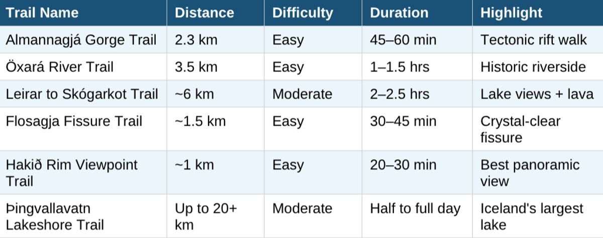
Thingvellir National Park Hiking Trail Map Overview
The park has a central visitor area near the Hakið Service Centre on the northern rim of the rift valley. Most hiking trails start from or connect to this area. There are also trailheads along the southern shore of Þingvallavatn and near the Silfra fissure.
You can pick up a free paper trail map at theHakið Visitor Centre or download one from the Thingvellir National Park official website before your visit. The map marks all signed trails, parking areas, facilities, and key landmarks. GPS on your phone also works well throughout the park as the trails are clear on most mapping apps.
Here is a quick summary of the main marked trails in Thingvellir:
Best Hikes and Trails in Thingvellir National Park
Here is a full breakdown of each main trail so you can decide which ones fit your time and fitness level.
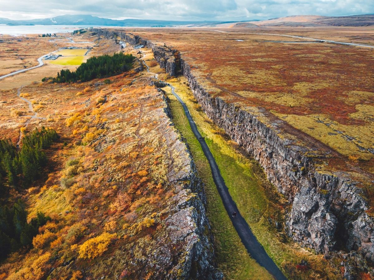
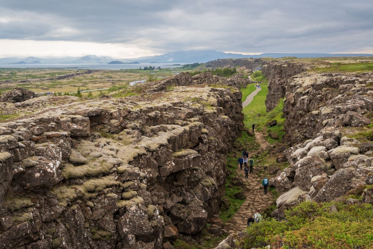
Almannagjá Gorge Trail — Walk Between Two Tectonic Plates
- Distance: 2.3 km one way (can be walked back or looped)
- Difficulty: Easy
- Duration: 45 to 60 minutes
- Trailhead: Hakið Visitor Centre car park
Almannagjá is the most iconic trail in the park. This gorge is the actual boundary between the North American and Eurasian tectonic plates, and the trail runs right through the rift. The walls on either side rise up to 30 meters, and the path follows the Öxará river as it flows southward through the gorge.
The trail is flat and well-paved through most of its length, making it suitable for all ages. Along the way, you pass Lögberg— the Law Rock — where the speaker of the Alþingi parliament would stand and recite laws to the assembled crowd. There is a flagpole marking the spot today.
You also pass Öxárárfoss waterfall, a small but pretty cascade where the Öxará river flows over the cliff edge into the gorge. This is one of the most photographed spots in the park. The trail ends near the lake at Neðri-Ás, where you can turn around or continue onto connecting paths.
Öxará River Trail — History and Calm Water Walking
- Distance: 3.5 km
- Difficulty: Easy
- Duration: 1 to 1.5 hours
- Trailhead: Connects from Almannagjá or Hakið car park
The Öxará River Trail follows the river from the gorge area down to where it meets the lake. The path is gentle, mostly flat, and runs through open lava fields dotted with birch trees and wildflowers in summer. This is one of the quieter trails in the park since most visitors stick to the gorge.
The river itself has a rich history. During the days of the Alþingi, it supplied freshwater to the camp. It was also the site of judicial punishments — drowning was a legal sentence for certain crimes for several centuries. Today it is simply a beautiful, calm river to walk alongside. Look for Arctic terns nesting near the water in summer.
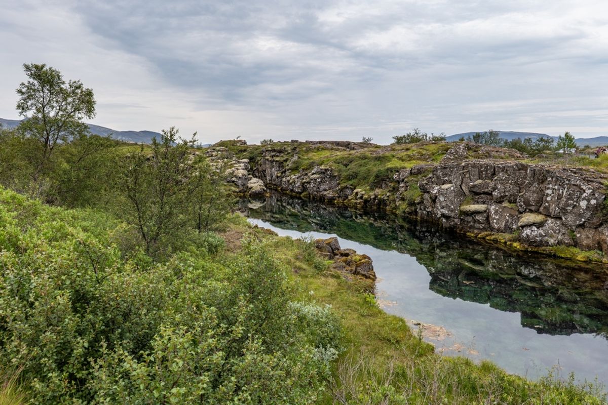
Flosagja Fissure Trail — The Clearest Water You Will Ever See
- Distance:~1.5 km
- Difficulty: Easy
- Duration: 30 to 45 minutes
- Trailhead: Silfra parking area, near Visitor Centre 2
Flosagja is a long, narrow fissure filled with some of the clearest water in Iceland. The trail runs along the edge of the fissure, giving you views down into the turquoise water below. The depth and clarity of the water here is extraordinary — you can see metres down into the fissure even on overcast days.
Right next to Flosagja is Silfra, the most famous diving and snorkeling site in Iceland. Silfra is a fissure between the two tectonic plates where glacial water from Langjökull glacier filters through the lava rock for decades before filling the fissure. The result is water with visibility exceeding 100 meters. It is consistently ranked among the top dive sites in the world.
Many visitors who come to hike around Flosagja also book a guided Silfra snorkeling or diving tour to experience the fissure from the inside. These tours provide all the equipment (you will need a dry suit since the water is around 2 to 4 degrees Celsius year-round) and are suitable for people with basic swimming ability, even without a formal diving certification for the snorkeling option.
Hakið Rim Viewpoint Trail — Best Panoramic View in the Park
- Distance:~1 km return
- Difficulty: Easy
- Duration: 20 to 30 minutes
- Trailhead: Hakið Visitor Centre, upper parking area
This short trail leads up to the rim of the rift valley and gives you a sweeping view across the entire Thingvellir plain. From up here, you can see the Almannagjá gorge cutting through the valley, Þingvallavatn lake gleaming in the distance, the small Þingvallakirkja church near the historic assembly grounds, and the distant Hengill volcano on the horizon.
It is the best place in the park to understand the scale of the rift valley. Do this trail first if you can — it helps you orient yourself for everything else.
Leirar to Skógarkot Trail — Lava Fields and Lake Views
- Distance: ~6 km one way
- Difficulty: Moderate
- Duration: 2 to 2.5 hours one way
- Trailhead: Leirar camping area, south of the main visitor zone
This trail takes you along the eastern edge of the valley and through ancient lava fields toward Skógarkot, a small farmstead area near the southern shores of the lake. The terrain here is rougher than the gorge trails, with uneven lava rock and some gentle elevation changes. You get excellent views over Þingvallavatn and the Hengill mountains. This is the trail to choose if you want a longer, quieter hike away from the busy central area.
Þingvallavatn Lakeshore Trail — Iceland's Largest Natural Lake
- Distance: Sections of 3 to 20+ km depending on the route chosen
- Difficulty: Easy to Moderate
- Duration: Half to full day for longer sections
- Trailhead: Multiple access points around the lake
Þingvallavatn is Iceland's largest natural lake at 84 square kilometers. Trails run along sections of its northern and eastern shoreline, and some connect to the main park trail network.
The lake is home to several unique species of fish found nowhere else on earth, including landlocked Arctic char that evolved in isolation after the last ice age. Walking along the shore in summer, with lupine flowers in bloom and the Hengill mountains reflected in the water, is genuinely memorable.
Thingvellir Hiking Trails Full Day Route

If you have a full day at Thingvellir, you can link several trails into a satisfying loop. Here is a recommended full day route that covers the best of the park without doubling back too much.
- Start at Hakið Visitor Centre— Park here and begin with the Rim Viewpoint Trail for the big picture view. Takes 20 to 30 minutes.
- Walk the Almannagjá Gorge Trail— Head down through the gorge, pass Lögberg, and walk alongside the river to Öxárárfoss waterfall. Allow 1 hour.
- Continue on the Öxará River Trail— Follow the river south toward the lake. Quiet, flat, and scenic. About 1 hour.
- Drive or walk to the Silfra / Flosagja area— Explore the Flosagja fissure trail. If you have pre-booked a snorkeling tour, do it here. Allow 1 to 3 hours depending on whether you snorkel.
What to Bring for Hiking Thingvellir National Park
The easy trails at Thingvellir do not require specialist hiking gear, but Iceland's weather changes fast. Here is what to pack for a comfortable day on the trails.
- Waterproof jacket and trousers
- Sturdy walking shoes or hiking boots
- Water and snacks
- Sunscreen and sunglasses
- Trail map or offline GPS
- Camera
Ready to Experience the Golden Circle?
Book your tour today and see these incredible sights with an expert local guide.
View Our Tours

