
Gullfoss formed where the glacial Hvítá river cuts through a stack of hard dolerite laid down between ice ages, with a thick layer of loose gravel and mudstone underneath it. The water strips out the soft layer, the hard rock above loses its support and collapses, and the waterfall retreats upstream one block at a time.
That process has carved Gullfossgljúfur, the canyon below the falls, which runs about 2.5 kilometres downstream with walls up to 70 metres high.
The falls drop in two stages, 11 metres then 20, according to the Environment Agency of Iceland. Together that is a little over 30 metres, which makes Gullfoss far from Iceland's tallest waterfall and comfortably among its most powerful.
The Hvita and Its Glacial Source
Everything at Gullfoss starts about 40 kilometres upstream, under an ice cap.
The Hvítá rises at Hvítárvatn, a lake at the eastern edge of Langjökull, Iceland's second largest glacier. Meltwater from the ice feeds the lake and the lake feeds the river.
The name means white river, and the colour is the giveaway. Glaciers grind the bedrock beneath them into a fine powder known as rock flour, which stays suspended in the water rather than settling out.
That suspended sediment does two things. It turns the water pale and milky, and it turns the river into an abrasive, because every cubic metre of Hvítá water carries grit past the rock face.
Flow averages 109 cubic metres per second, rising through the summer melt and reaching 2,000 in the largest floods on record. A river carrying that much sediment at that rate is a cutting tool rather than a stream.
The Rock Layers Behind the Falls
This is the part you can actually see from the viewpoint, once you know what to look for.
The lip of the falls is dolerite, a hard, dense volcanic rock formed from lava that cooled slowly underground. It sits in layers, laid down during the warm interglacial periods of the last ice age, with sediment sandwiched between them.
Beneath the dolerite is a band of conglomerate, mudstone and gravel roughly 10 metres thick. About 8 metres of it are visible in the face of the waterfall itself, and it thickens to around 40 metres further down the canyon.
The gravel layer contains loose lenses that the water removes easily. That is the whole mechanism: the soft layer washes out, the hard cap is left unsupported, and eventually a slab of dolerite drops into the river.
Geologists call this differential erosion, and it produces the same stepped profile at waterfalls all over the world. Gullfoss is an unusually clear example because both layers are exposed in the same face.
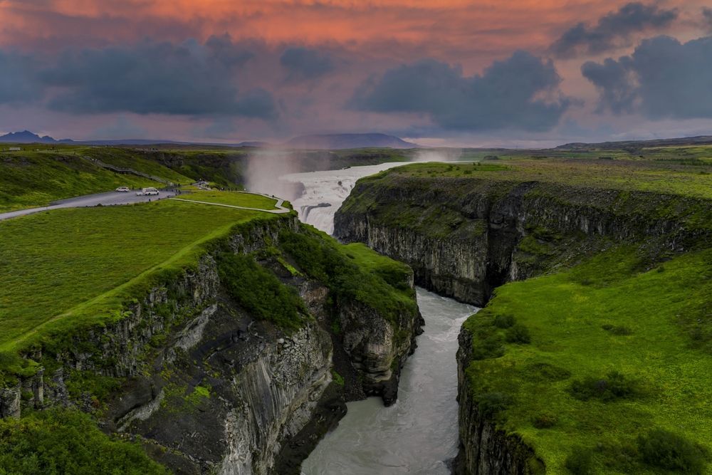
Gullfossgljúfur runs about 2.5 kilometres downstream with walls reaching 70 metres.
Why Gullfoss Has Two Tiers
The stepped shape follows the rock, and the right-angle turn follows something older.
The upper fall drops 11 metres over one dolerite ledge. Below it the river runs a short distance across a shelf, then drops 20 metres over a second ledge into the canyon proper.
Two ledges means two resistant layers separated by softer material, each eroding back at its own rate. Where the layers are thicker or harder, the step is taller.
The famous part is what happens next. The river turns almost 90 degrees at the base of the lower fall and disappears into a narrow gorge running crossways to the direction of flow.
From the upper viewpoint this makes the water look as though it is vanishing into the ground, which is the photograph everyone takes and the thing nobody can quite explain in the moment.
The turn exists because the canyon follows a line of weakness in the rock rather than the river's own gradient. The water goes where the rock lets it go.
Two Explanations for the Canyon
Here the science is genuinely unsettled, and the honest answer is more interesting than a tidy one.
The dramatic explanation is a jökulhlaup, a glacial outburst flood. At the end of the last ice age, subglacial lakes around Langjökull released catastrophic volumes of water in short bursts, and floods of that scale can cut a gorge in days rather than millennia.
The gradual explanation is simpler. The Hvítá has been running here since the ice retreated roughly 10,000 years ago, and steady headward erosion through a weak gravel layer is enough to produce 2.5 kilometres of canyon over that time.
The Environment Agency notes both and considers the gradual account the more credible of the two.
Both mechanisms may have contributed, which is the usual answer in Icelandic geology. Floods do the spectacular work and ordinary river erosion does the rest.
What is not in doubt is the direction. The canyon was cut from the bottom up, with the waterfall retreating upstream and leaving the gorge behind it.
A Waterfall Still on the Move
Gullfoss is not a finished landform, which is a strange thing to stand next to.
Every collapse of the dolerite cap moves the lip of the falls a little further upstream and adds a little more length to the canyon. The gorge below you is the record of where the waterfall used to be.
The rate is not something you would notice in a lifetime. Over 10,000 years, 2.5 kilometres works out at roughly 25 centimetres a year on average, and the real process happens in irregular jumps rather than steadily.
Flood years do most of the work. A season that touches 2,000 cubic metres per second moves more rock than a decade of ordinary flow.
River discharge is monitored continuously, and the Icelandic Met Office runs the hydrological network that records those peaks on the Hvítá and elsewhere.
Winter helps too. Water freezing in cracks in the dolerite prises blocks apart, so the freeze-thaw cycle prepares the rock that the summer flood then removes.
Given long enough, Gullfoss will retreat far enough upstream to reach a different rock sequence, and it will stop looking like this. That is a very long time away.
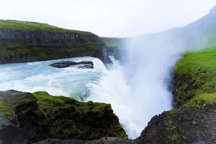
The canyon below the falls is a record of where the waterfall stood in the past.
Why the Water Looks Golden
The name means golden falls, and there are three competing accounts of where it comes from.
The sediment explanation is the geological one. Rock flour suspended in the water gives it a brownish, ochre cast that turns genuinely gold in low sun, particularly in late afternoon.
The rainbow explanation is the one you see on a clear day. Spray from the lower tier produces near-permanent rainbows across the canyon when the sun is out, and gold sits in the middle of them.
The folklore explanation involves a local farmer who is said to have thrown a chest of gold into the falls rather than let anyone inherit it. This is a good story and there is no evidence for it.
The first explanation is the one that holds up. On an overcast day the water looks grey-brown, which is exactly what suspended basalt powder should look like without sun on it.
The name and the story behind the falls are covered in more detail in our piece on how Sigríður Tómasdóttir saved Gullfoss, which is the other half of what makes this site worth an hour.
How the Golden Circle Fits Together Geologically
The three main stops are the same story told three ways, which is the underrated thing about this route.
Þingvellir is the plate boundary itself, where the North American plate pulls away from the Hreppar microplate and the rift valley drops between them. The park sits on the Atlantic ridge that runs through Iceland, and the gorges and cracks along the valley floor are the surface expression of it according to Þingvellir National Park.
Geysir is the heat, where groundwater meets a shallow magma system and Strokkur turns that into an eruption every five to ten minutes.
Gullfoss is the water, showing what a glacial river does to volcanic rock once the ice has gone.
Seen in that order, the loop moves from the forces that build Iceland to the forces that take it apart. Our guide to what the Golden Circle covers sets out the route itself.
The whole region sits on the volcanic zone that runs diagonally across the country, which is why three sites this different are within an hour of each other.
Seeing the Geology for Yourself
Four things to look for when you are standing there, none of which need any equipment.
From the upper viewpoint, find the horizontal banding in the canyon wall opposite. The darker resistant bands are dolerite and the paler crumbling sections between them are the sediment layers.
At the lip of the upper fall, look at the blocky, angular edge. That shape comes from slabs breaking away along joints rather than the rock being worn smooth.
Look downstream along the canyon. It is narrow, steep-sided and roughly constant in width, which is the signature of a gorge cut by headward retreat rather than one widened by a river over time.
Look at the water itself, ideally with a hand in it if you can reach the spray. The gritty feel is the rock flour, and it is the reason any of this happened.
The lower path gets you closest to the rock face, though it closes in ice and high water. Our classic Golden Circle tour allows enough time at the falls to walk both viewpoints rather than one.
Stand at the Edge of a Working Landscape
Gullfoss is one of the few places where you can watch geology happening rather than read about the result. Our small-group Golden Circle tour with Kerið and Friðheimar keeps groups under twenty and gives you the time at the canyon to actually look at the rock layers, with a guide who can point out what you are seeing. Tell us your dates and we will find you a departure.
Compare Golden Circle Tours
Check each selected product for its current operator, guide, itinerary, meeting point, and terms.
View Our Tours