
The Golden Circle is usually done from a car. You park, you walk to the viewpoint, you drive to the next stop. That version of the route is fine. But the area around Þingvellir, Geysir, and Gullfoss contains hiking trails that most visitors never find, and some of them are genuinely extraordinary.
Walking the full Þingvellir gorge, following the Brúará river to Iceland's bluest waterfall, soaking in a river at the end of a 3 km climb through a steam valley: none of these appear on most Golden Circle itineraries and all of them are worth more than another hour in the car.
These are the ten best hikes in and around the Golden Circle, from quick viewpoint walks to full-day mountain ascents.
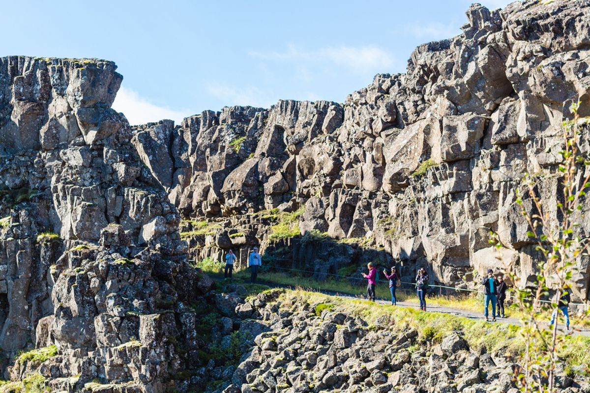
1. Almannagjá Gorge Trail, Þingvellir National Park
- Distance: 3.5 km one way
- Difficulty: Easy
- Time: 1 to 1.5 hours one way
- Trailhead: Hakið parking area (P1), Þingvellir
The gorge walk most visitors do in part and should do in full. The Almannagjá canyon runs along the edge of the North American tectonic plate with the wall on one side and the rift dropping away on the other. The path begins at the main parking area and follows the gorge south, passing the Law Rock (Lögberg) where Iceland's ancient parliament convened from 930 AD, before ending at the Öxará River.
From the river, a short detour leads to Öxarárfoss waterfall, which drops into the rift valley and partially freezes in winter. Most visitors turn around at the Law Rock and miss both the waterfall and the quieter southern section of the gorge where the tectonic character of the landscape is most visible.
Walk the full trail rather than the first 15 minutes and back. The difference in experience is significant.
Best season: Year-round. Microspikes recommended in winter on icy sections.
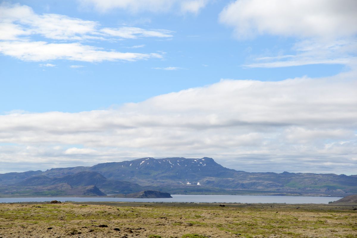
2. Þingvallavatn Lakeshore Trail
- Distance: 4 to 8 km depending on how far you walk
- Difficulty: Easy
- Time: 1.5 to 3 hours
- Trailhead: Multiple access points from the main Þingvellir visitor area
The lake trail follows the northern shore of Þingvallavatn, Iceland's largest natural lake, through open lava field and low birch scrub. Almost no other visitors use it even when the gorge is busy. The path gives views across the water toward the Hengill volcano massif to the south and along the rift valley walls to the west.
In September and October, the birch scrub along the shore turns vivid gold and rust. Birdlife is consistent throughout the year. Arctic foxes are occasionally seen in the surrounding lava field. The lake itself is geologically active with springs feeding directly into it from below.
This works well as a second hour after the gorge walk, giving a completely different perspective on the same park.
Best season: May through October. Some sections are boggy after snowmelt.
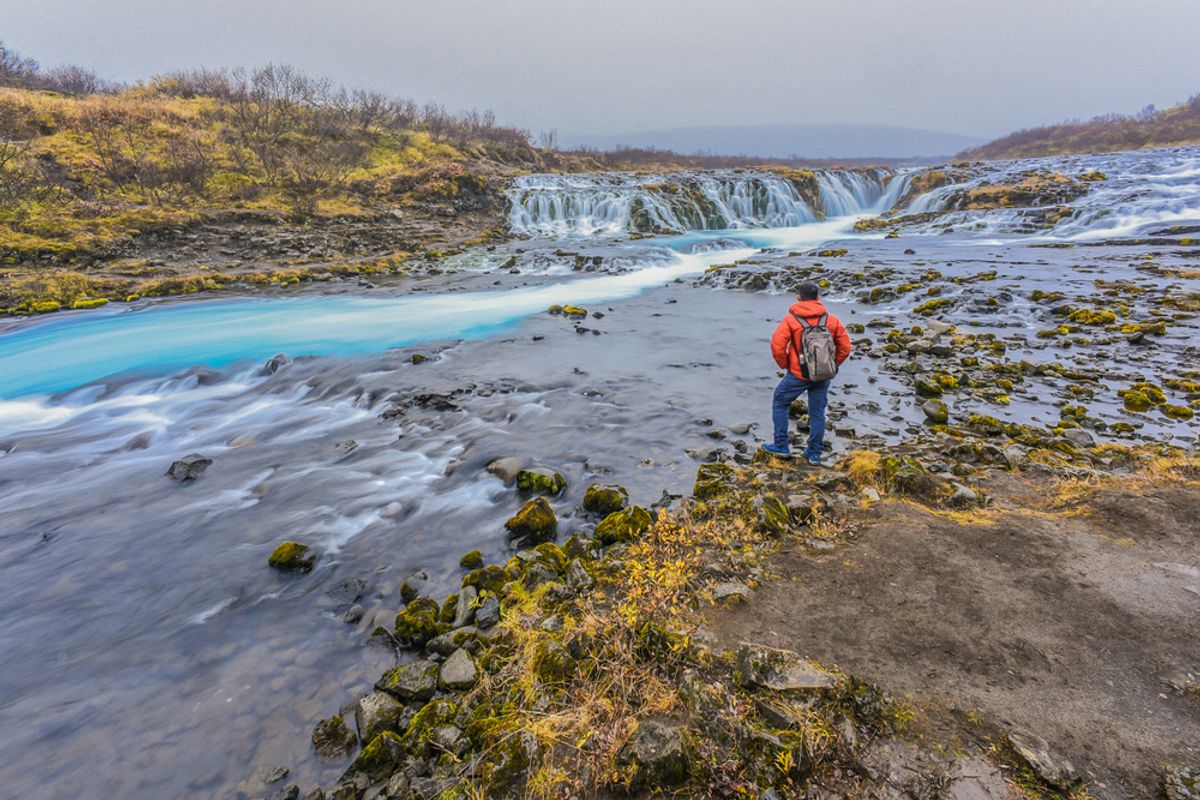
3. Brúarfoss Waterfall Trail
- Distance: 1.2 km (short route) or 5 km round trip (full river walk)
- Difficulty: Easy
- Time: 30 minutes (short) or 2 to 2.5 hours (full walk)
- Trailhead: Brúarfoss parking area on Route 37, between Þingvellir and Geysir
The most underrated stop on the entire Golden Circle circuit. Brúarfoss is called Iceland's bluest waterfall, and the description is accurate. The Brúará river runs an electric, luminous blue from glacial meltwater filtered through volcanic rock, and the waterfall itself drops through a narrow slot in dark basalt into the same vivid blue pool below.
Tour operators drive past the parking sign. On a busy summer Saturday at Geysir 15 minutes away, Brúarfoss will often be empty.
The short route from the signed parking area on Route 37 is a flat 600-meter walk to the main viewpoint: 30 minutes return and suitable for anyone. The longer route follows the river upstream from a lower parking area, passing Hlauptungufoss and Miðfoss waterfalls before reaching Brúarfoss: three waterfalls in the same extraordinary blue on a single trail.
Best season: Year-round. The blue color is vivid in every season and particularly striking against winter snow.
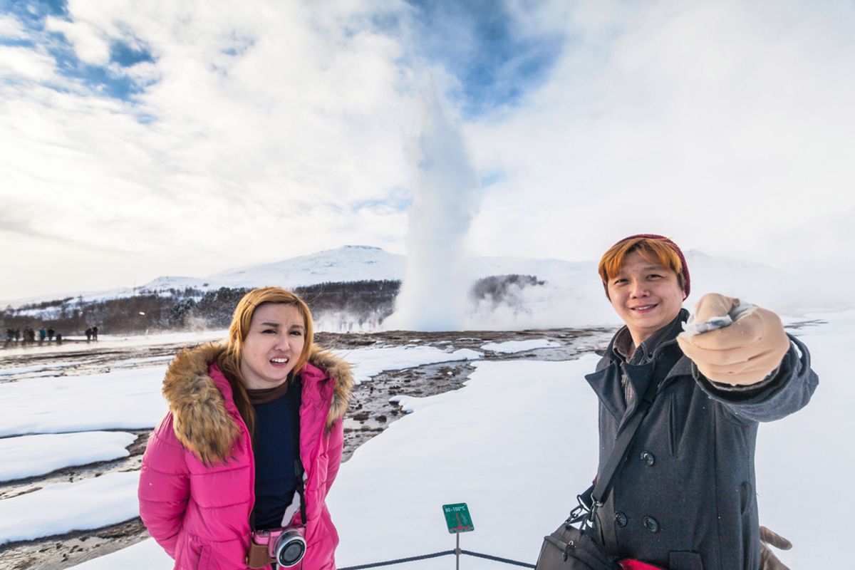
4. Geysir Geothermal Field Extended Walk
- Distance: 2 to 3 km depending on route
- Difficulty: Easy
- Time: 45 to 90 minutes
- Trailhead: Geysir Center car park
Most visitors watch Strokkur erupt twice and return to the car. The geothermal field has several kilometers of marked paths covering features most visitors never reach.
The extended walk passes Blesi, two adjacent pools at different temperatures and clarity that look like they are lit from within. One is clear enough to see the bottom at several meters depth; the other is opaque and turquoise. Beyond Blesi, the dormant Geysir crater is the largest feature in the field and accessible on the longer marked path. The elevated sections of the field give overview perspectives across all the active springs simultaneously.
Staying on marked paths is essential throughout. The ground between the hot springs is thin in places over boiling water and the warning signs are not precautionary.
Best season: Year-round. Steam effects are most dramatic in cold weather and the field looks most active in winter.
5. Gullfoss Canyon Rim Walk
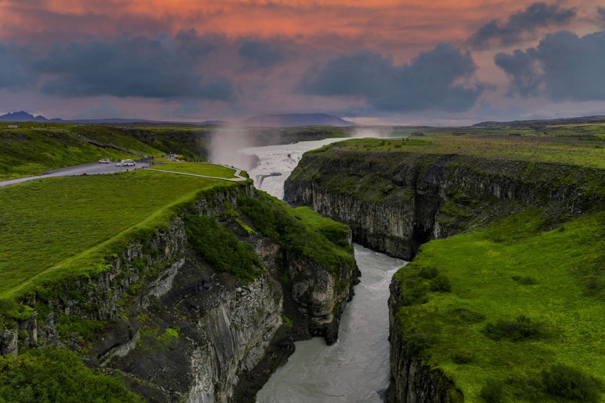
- Distance: 2 to 3 km
- Difficulty: Easy
- Time: 45 to 60 minutes
- Trailhead: Gullfoss upper viewing platform
The canyon rim walk extends east from the main Gullfoss viewpoints along the edge of the Hvítá canyon. Most visitors stop at the two main platforms and return to the car. Continuing past the upper platform and along the rim takes you to progressively quieter viewpoints with the falls visible from different angles and the canyon stretching away to the east below you.
The light along the rim in late afternoon in winter is exceptional. The low sun hits the canyon walls and the ice formations at golden-hour angles for most of the afternoon, something that summer's overhead light never produces. The further you walk from the main platform, the fewer people you share it with.
The path is maintained to the main viewpoints. Further along the rim it becomes a rough track. Good footwear with ankle support is appropriate. In winter, microspikes are useful beyond the maintained section.
Best season: Year-round. Winter gives the best light and ice formations. Summer is busiest at the platforms but quieter along the rim.
6. Reykjadalur Hot Spring River Trail
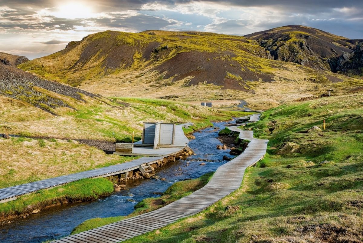
- Distance: 6 km round trip
- Difficulty: Easy to moderate
- Time: 2 to 3 hours including bathing
- Trailhead: Edge of Hveragerði town, off Route 1 south of the Golden Circle
The trail that ends in a bath. Reykjadalur (Steam Valley) is a geothermal river valley behind Hveragerði, 45 minutes from Reykjavik on the return from the Golden Circle. The path climbs steadily for 3 km through a landscape of steam vents, mud pools, and hot springs. At the top, the Reykjadalur river runs warm.
There are no facilities at the bathing area. You change at the riverbank, wade in, and find the right temperature by moving along the bank (hotter upstream, cooler downstream). The surrounding hills vent steam continuously. On winter days, the contrast of warm water, cold air, and steam rising from every hillside is one of Iceland's most specific sensory experiences.
This works best as a final stop on the return to Reykjavik from the Golden Circle via Route 1.
Best season: Year-round. Summer is most comfortable. Winter is more dramatic but the trail can be icy.
7. Kerið Crater Rim and Lake Walk
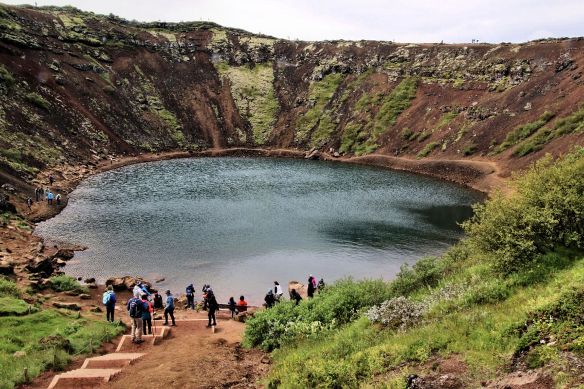
- Distance: 1.5 km round trip
- Difficulty: Easy (rim) / moderate (descent to lake)
- Time: 30 to 45 minutes
- Trailhead: Kerið car park on Route 35
- Admission: ISK 400 per person
Kerið is treated as a five-minute viewpoint by most Golden Circle drivers. Walking the full rim and descending to the lake makes it a proper short hike.
The rim path circles the crater at 55 meters above the lake, giving continuously changing views of the vivid red and ochre volcanic walls against the turquoise-green water. The descent path to the lake is steep and can be icy in cold months. From the lake edge, looking up at the crater walls is a completely different visual experience from the rim view and gives a better sense of the scale of the volcanic event that created it.
In winter, the lake partially freezes and takes on a pale blue-green color. The ice against the red volcanic soil is one of Iceland's more unusual winter sights.
Best season: Year-round. Exercise caution on the descent path in icy conditions.
8. Hengill Volcano Hiking Area
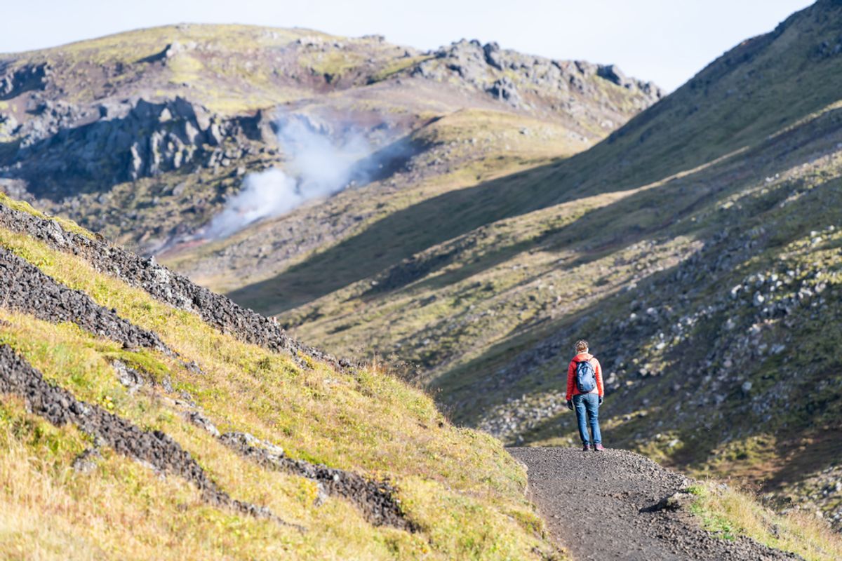
- Distance: 5 to 15 km depending on route
- Difficulty: Moderate to challenging
- Time: 3 to 6 hours
- Access: From Nesjavellir geothermal power plant or Hellisheiði, both within 40 minutes of Þingvellir
Hengill is an active volcanic system rising to 803 meters between Þingvellir and Hveragerði. The geothermal energy from Hengill heats Reykjavik and the surrounding region. Hiking across it puts you in a landscape of active fumaroles, vivid hot spring areas, and lava fields with panoramic views over Þingvallavatn.
The trail from Nesjavellir gives elevated lake views almost immediately. The route toward the summit ridge crosses increasingly volcanic terrain with steam venting from the ground on both sides of the path. The full traverse from Nesjavellir to Hveragerði is 15 km and drops 600 meters on the Hveragerði side.
Navigation requires a downloaded map. The area is not well-signposted compared to the main Golden Circle trails and trails marked on apps do not always match what is on the ground.
Best season: June through September. Higher routes are snow-covered and difficult to navigate in winter without mountaineering experience.
9. Skálholt Cathedral Walk and Valley Trail

- Distance: 2 to 4 km
- Difficulty: Easy
- Time: 1 to 2 hours
- Location: Biskupstungur valley, off Route 35, approximately 15 minutes from Geysir
Skálholt was Iceland's episcopal seat and the most powerful religious site in the country for over 800 years. The current cathedral dates to 1963. Below it, excavations have revealed the foundations of medieval structures and a bishop's sarcophagus is displayed in the crypt.
The walk around the cathedral grounds and along the Hvítá River valley below is quiet, historically significant, and almost always uncrowded. The valley landscape of the Biskupstungur area is characteristically Icelandic: low green hills, the river running clear, and distant highland views to the north.
Worth 45 minutes on the return from Geysir for anyone interested in historical Iceland rather than just the geological attractions.
Best season: Year-round. Cathedral and crypt have seasonal opening hours: check before visiting.
10. Bláfell Mountain Summit, Þingvellir
- Distance: 10 km round trip
- Difficulty: Challenging
- Time: 4 to 6 hours
- Trailhead: Eastern Þingvellir National Park access points
Bláfell is a 1,000-meter mountain on the eastern edge of Þingvellir National Park. The summit gives the most comprehensive panoramic view in the Golden Circle area: Þingvallavatn lake below, the full Þingvellir rift valley, the Hengill massif to the south, and on clear days Snæfellsjökull glacier on the Snæfellsnes Peninsula across the bay.
The trail ascends steadily for 5 km one way through volcanic rock and alpine vegetation. The upper sections are steep and require good footwear with ankle support. Navigation on the upper mountain requires basic map reading. The summit is exposed to wind in all directions.
This is a full-day commitment that does not combine well with the standard Golden Circle driving loop. Best treated as a dedicated hiking day focused on Þingvellir rather than added to an already full itinerary.
Best season: June through September. Not suitable without mountaineering experience in winter.
Ready to Experience the Golden Circle?
Book your tour today and see these incredible sights with an expert local guide.
View Our Tours

