
Can You Walk Between Two Tectonic Plates at Thingvellir?
You can walk across the rift valley that the plates have opened, which is not quite the same as stepping over a line. Þingvellir sits on the Mid-Atlantic Ridge, and the boundary here is a zone several kilometres wide rather than a single crack.
The valley floor between the Almannagjá cliff in the west and Hrafnagjá in the east is around seven kilometres across, and the whole strip has subsided as the two sides pulled away from each other.
Walking the Almannagjá path puts you against the edge of the North American plate, with the rest of the rift stretching out below you. That is the honest version of the claim, and it is more impressive than the marketing one.
Which Plates Actually Meet Here
The standard answer is North American and Eurasian, and it needs one correction.
Iceland straddles the boundary between those two major plates, which is why the island exists at all. Magma rises along the ridge and builds new crust faster than the sea can erode it.
At Þingvellir specifically, the eastern side is not the Eurasian plate proper. Silfra sits in the rift that separates the North American plate from the Hreppar microplate, according to Þingvellir National Park.
The Hreppar microplate is a wedge of crust caught between two branches of the ridge in southern Iceland, moving semi-independently of both major plates.
None of this diminishes what you are looking at. You are standing in an active spreading zone that is above sea level, which is true almost nowhere else on Earth.
What the Rift Valley Actually Looks Like
The shape is easier to read once you know what produced it.
Two parallel cliff walls run north to south. Almannagjá on the west side is the dramatic one, a rock face rising up to 40 metres in places, and Hrafnagjá on the east is lower and less visited.
Between them the ground has dropped. The land subsides across that seven kilometre stretch because the crust is being stretched, thinned and pulled down as the sides move apart.
The floor of the valley is not flat. It is cut by dozens of smaller fissures running parallel to the main walls, some narrow enough to step over and some filled with water.
Þingvallavatn, Iceland's largest natural lake, occupies the southern end of the valley, which is the lowest part of the whole structure.
Above the western wall, at the visitor centre, you get the view that explains the geology in about three seconds. Our page on Þingvellir National Park covers the layout and the parking.
How Fast Are the Plates Moving?
Slowly enough that nothing you see today will change, and fast enough that the valley is measurably different from a century ago.
The spreading rate along this section of the ridge averages roughly two centimetres a year. That is about the rate a fingernail grows.
The movement is not smooth. Stress builds along the fissures for decades and then releases in earthquakes, which is when the valley actually widens.
Iceland's seismic network records this continuously, and the Icelandic Met Office publishes live earthquake data for the whole country.
Since the Alþingi assembly first met here around 930, the valley has widened by roughly 20 metres on that average. The gorge you walk through has been getting wider the whole time humans have been using it.
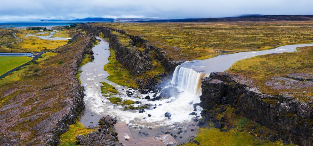
Between the two cliff walls the ground has dropped across a seven kilometre stretch.
Walking the Almannagja Gorge
The single best half-hour on the Golden Circle, and it is downhill.
Start at the upper car park beside the visitor centre. The paved path drops through a cut in the cliff face and then runs along the base of it towards the valley floor.
The walk down takes about 15 minutes at a normal pace, with viewing platforms and interpretation boards along the way. It is paved, gently graded and manageable with a pushchair.
At the bottom you reach Lögberg, the Law Rock, where the assembly's lawspeaker recited the law from memory each year. The Alþingi met here from around 930 until 1798 according to the park's own history.
From Lögberg the path continues across the valley floor towards the church and the old farm buildings, which is another 15 minutes.
The return climb is the part people forget when planning. Either walk back up the same route or arrange to be collected from the lower car park.
Öxarárfoss and the Fissures
Two things worth the short detour from the main path.
Öxarárfoss drops over the Almannagjá wall about ten minutes' walk north of the top of the gorge, along a boardwalk. The river was diverted here centuries ago to supply the assembly with water.
The fall is modest at around 13 metres, and the setting inside the rift wall is what makes it. Our page on Öxarárfoss covers the boardwalk and the winter access.
In the cold months it freezes into a column and the walkway ices over, which is when the handrails earn their place.
Peningagjá, the coin fissure, sits along the road across the valley floor. It is a water-filled crack of extraordinary clarity, and the coins on the bottom are visible several metres down.
Flosagjá and Nikulásargjá are the other named fissures near the main path, and both show the same pattern: a vertical crack in the lava, filled with groundwater that has filtered through the rock for decades.
Silfra: The Rift Underwater
The most direct way to be between two plates, and the coldest.
Silfra is a fissure filled with meltwater from Langjökull that has spent 30 to 100 years filtering through porous lava before it arrives. That filtration is why the visibility runs to 100 metres and beyond.
The water sits at 2 to 4°C year-round. Snorkellers wear a drysuit over thermal layers, so only your face and hands are exposed.
The route drifts through four sections, including the narrow Silfra Hall and the famous Big Crack where the walls close to within arm's reach on both sides.
In that section you genuinely are between the North American plate and the Hreppar microplate, with a hand on each wall. It is the version of the claim that survives scrutiny.
Snorkelling needs no experience beyond being comfortable in water, and the Silfra fissure has a minimum age of 12 and a requirement to be able to swim.
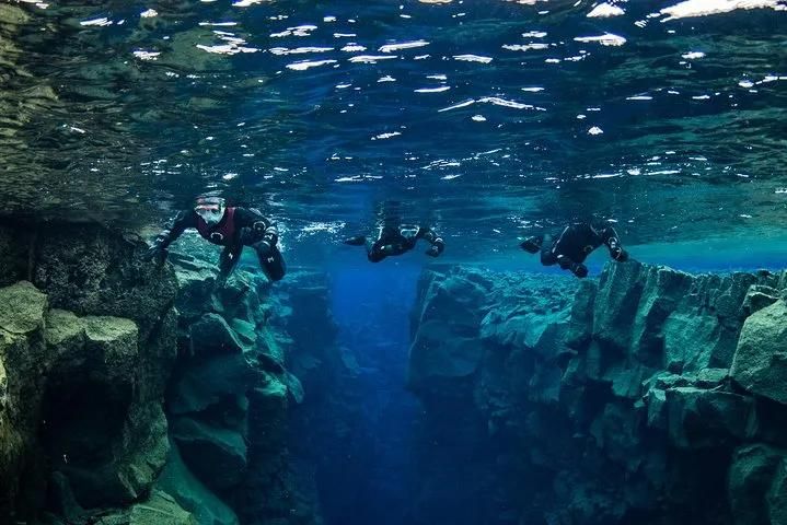
In the Big Crack the walls come close enough to touch both sides at once.
Best Viewpoints and Routes
Four ways to see it, in ascending order of effort.
The upper viewpoint at the visitor centre gives the whole valley in one frame, with the lake at the far end. Two minutes from the car park and fully accessible.
The Almannagjá path is the classic route, 15 minutes down through the gorge to Lögberg.
The valley floor loop takes an hour and links the church, the old farms, the fissures and the assembly site along level paths.
The Hrafnagjá wall on the eastern side is reached by road and is almost empty, because nearly everyone stops at the western wall and leaves. It gives the reverse view across the rift.
For a longer walk, marked trails run north from the park towards Skjaldbreiður, the shield volcano whose lava built the valley floor.
Practical Points
Six things worth knowing before you arrive.
Parking costs 1,000 ISK, paid at the machine or online, and it covers the day across all the park's car parks. Holders of a disabled parking permit are exempt.
Entry to the park itself is free. The charge is for parking only.
The visitor centre at the upper car park has toilets, an exhibition and a café, and the toilets on the valley floor are more limited.
Allow 1 to 1.5 hours for a standard visit. That covers the viewpoint, the gorge walk and Lögberg without rushing.
Wind funnels along the rift, so the gorge is often colder than the car park. A windproof layer matters more than a thick one.
Silfra is booked separately and needs 2.5 to 3 hours including briefing and kit, so it does not slot into a standard Þingvellir stop.
Seeing It on a Golden Circle Day
Þingvellir is the first stop on the standard loop, and there are reasons for that beyond geography.
It needs walking, which is better done early while everyone still has the legs for it. Our guide to what the Golden Circle covers sets out the full route and the drive times.
It also reads better in good light. The rift walls are grey basalt and they look flat under a heavy sky, so an early start in summer helps.
Geysir is 50 minutes east and Gullfoss ten minutes beyond that, which makes the three of them a comfortable day with room for one more stop.
Adding Silfra changes the arithmetic entirely. A snorkelling morning plus the rest of the loop is a 10 hour day rather than an 8 hour one.
Our Golden Circle and Silfra snorkelling tour combines the two with lunch at Friðheimar, which is the efficient way to do both in one trip.
Stand in the Rift Yourself
Þingvellir is the only place where a mid-ocean ridge sits above sea level and you can walk down into it on a paved path. Our small-group Golden Circle tour with Kerið and Friðheimar keeps groups under twenty and allows enough time at the park to walk the gorge properly rather than photograph it from the top. Tell us your dates and we will find you a departure.
Compare Golden Circle Tours
Check each selected product for its current operator, guide, itinerary, meeting point, and terms.
View Our Tours
